5,249 ft. Elevation? No Problem.
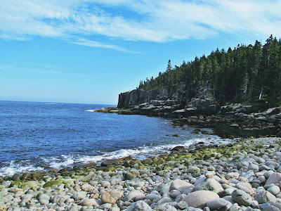
Back in July, my boyfriend and I took on a trail rated as one of 20 dream trails by National Geographic. We ventured the Franconia Ridge loop in New Hampshire. The hike takes you up to Little Haystack Mountain, Mt. Lincoln, and Mt. Lafayette. This loop is about 9 miles, including about 3,500 ft. elevation gain in just about five miles. Though the hike was tough, it was without a doubt worth the struggle.
 Preparations
The night before we planned on hiking, we camped about 15 minutes from the trail head. We were without cell phone signal, so the weather forecast that we had to go off of was from a day or two before our hike. The forecast had called for rain in the mid to late afternoon. Knowing the nature of the trail and potentially dangerous conditions at the summit, our plan was to get on and off the trail before it would rain.We drove over to the trail in the morning, packed and prepared with plenty of food, water, and safety items for a strenuous day hike. The trail head was very easy to find, as there is a parking lot right off of I-93. Once we were all set, we set out on our journey.
Starting the Hike
Since the hike is a loop, one can choose to start going in either direction. We chose to start by veering to the right onto the Falling Waters Trail. The trail is about three miles and is very rocky all throughout the hike. This section includes steep elevation gain, particularly after the first mile or so. It leads straight up to the summit of Little Haystack Mountain. I'm a giant baby with mediocre cardio, so I really struggled going up this part.
A very big plus side to this part of the hike is that there are some lovely waterfalls along the way. Cloudland Falls and Stairs Falls were both very pleasant to encounter along the trail. Being that the trail goes right up along these falls and the brook that forms them, many of the rocks on the trail are wet. It's something to keep in mind, being that the trail can be slippery even when it hasn't recently rained.
A very big plus side to this part of the hike is that there are some lovely waterfalls along the way. Cloudland Falls and Stairs Falls were both very pleasant to encounter along the trail. Being that the trail goes right up along these falls and the brook that forms them, many of the rocks on the trail are wet. It's something to keep in mind, being that the trail can be slippery even when it hasn't recently rained.
Franconia Ridge Trail
After getting up to Little Haystack, you turn onto the Franconia Ridge Trail. This trail is also part of the Appalachian Trail. By this point, you're past the treeline and on exposed trail. I had never previously hiked beyond the treeline, so this experience was new and breathtaking. Literally. I felt sick-- some kind of mixture between altitude sickness and vertigo maybe? Being able to see mountains and more in all directions is an unforgettable sight. Eventually I felt better, but I did need to take a rest a few times.
Although we were up on the ridge now, there was still a fair bit of elevation gain and loss over this nearly two mile stretch. Mt. Lincoln is the next peak that we reached. As we moved higher and higher, we began hiking through low-level clouds. It killed the view, but proved to be an interesting and memorable experience. It got quite cold as well, though it wasn't necessarily a bad thing being that we had just scaled a mountain ridge and could use a cool-down.
Finally, we got up to the tallest peak in the White Mountains outside of the Presidential Range-- Mt. Lafayette. The elevation at the summit is 5,249 ft. We started at 1,770 ft. There is a rest area up there where we ate some food. There were a few people up there with us as well, but it was not crowded by any means.
Getting Down
As much as we would have liked to hang out at the top a while longer, we feared that the clouds may mean that the rain was close. We still had about four miles left of the hike. While still on top of Mt. Lafayette, we had to make sure we were headed back down on the correct trail, as the Appalachian Trail continues on the ridge in a different direction. Continuing on the Greenleaf Trail, we started our descent. Once we got out of the clouds, we had stellar views once again. After about a mile, we reached the Greenleaf Hut, which is run by the Appalachian Mountain Club. You can make reservations to sleep here or stop for a snack. We continued onto the Old Bridle Path though to wrap up our hike.
The Old Bridle Path is three miles of navigating down steep rocks. It's not an exposed trail anymore, but tripping could get you a broken ankle. This section of the hike was more strenuous than I expected it to be. Normally I only really struggle with elevation gain, but going back down proved to be painful and time consuming. Eventually, we did make it down though and back to our car without injury.
Conclusion
Had the rain started while we were still on the ridge, it would have been perilous to stay up there and even more slippery when coming down. Luckily, the rain held off long enough for us to get back to our camp site and cook up a good meal.
 Knowledge is power-- if you are considering doing this hike (or any strenuous hike), be aware of conditions, hard sections of the hike, recommended skill levels, etcetera. I would not recommend the Franconia Ridge Loop for folks who are not in decent shape. You should have good knees, or be prepared with pain killers and to possibly face the physical consequences once the hike is all done. This trail would be difficult and dangerous for young children. If you are considering bringing your child, be conscious of their ability level before taking them out there. With the amount of steep, sometimes slippery, rocks and nearly two miles of exposed trail, over estimating your or your group's ability level can be deadly.
If you are up to the challenge though, this hike will be an unforgettable experience for you. Have a blast!

If you are up to the challenge though, this hike will be an unforgettable experience for you. Have a blast!


Comments
Post a Comment